Friday, June 30, 2023

LEPIDOLITE: A MUCH SOUGHT-AFTER MINERAL THESE DAYS

Lepidolite belongs to the mica group of minerals characterized by their “shiny” appearance. This group encompasses muscovite, biotite, and other similar “soft” minerals (i.e., “soft” in the sense of being easily scratched by a knife blade). Muscovite is clear to brownish, biotite is brownish to dark brown, but lepidolite is a lilac gray, rose-colored, pale yellow, or even pale gray member of the mica group.


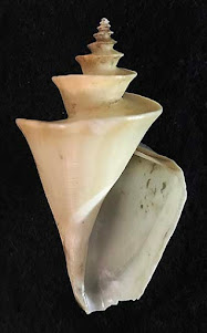
Shown above are three views of a hand-specimen (2.3 inches wide by 2.5 inches long) of lepidolite that the author collected, with permission, from mined material taken from pegmatite dikes at the Stewart Mine, near Pala, San Diego County, California. The associated red-colored mineral is rubellite (a gemstone of the mineral tourmaline). See one of my previous posts (Sept. 3, 2016), which concerns rubellite.


Lepidolite consists of the elements: potassium, aluminum, silicon, oxygen, as well as lithium, rubidium, and fluorine. Leipidolite is the most abundant lithium-bearing mineral, yet leipidolite is rare. This mineral usually occurs in fine to medium-grained crystalline aggregates, as shown in the images above. Large crystals are much rarer than in the other micas. The hardness of lepidolite is approximately 2.5.


SOME ADDITIONAL INFORMATION ABOUT THE ELEMENT LITHIUM:


Lithium has an atomic number 3. It is a soft, silvery-white alkali metal that reacts vigorously with water, and is the least dense metal. It occurs in 1) very low concentrations in igneous rocks, 2) in complex granitic pegmatites [via late-stage hydrothermal fluids], and 3) in brine waters of that accumulate in salt desert lagoons (salars). The salt-laden waters are then pumped to the surface in places like the Atacama Desert in Chile, South America.


 Google Earth Pro satellite image (2015) of much of South America, showing where one of the main active salt deserts east of the town of Antofagasta, Chile. Runoff waters from the nearby mountains, drain into the adjacent desert floor, where flamingo birds have lived for millennia. As mentioned in my next post, flamingoes are sustained by eating the brine shrimp in these salty waters. In the last 20 years or so, the brine waters have locally been pumped into evaporation pools for further evaporation, thereby increasing the concentration of brine waters containing dissolved salts containing lithium. Eventually the concentrated fluids are shipped to processing plants in order to extract the lithium.


Chile, Australia, China, and Argentina have the largest known reserves of lithium, with Chile (brine waters) and Australia (ore mining) having the most. The USA is not a significant producer of lithium. A few states (Arkansas, California, Nevada, North Carolina, and Utah) have some deposits, but this element is derived mainly from salt deserts in Chile and Argentina.


Lithium has excellent conductivity, thus it is used in the manufacturing of rechargeable batteries. More and more, it is in demand for making batteries used in making electric vehicles, computers, and cell phones. This element is also used in making glass, ceramics, and polymers, as well as being used in medicines. 


Literature consulted:


Wikipedia


Berry, L.G. and B. Mason. 1959. Mineralogy: concepts, descriptions, and determinations. W.H. Freeman and Company, San Francisco. 630 pp. 

Wednesday, June 21, 2023

THREE FAMOUS SEASHELLS FORMERLY BELIEVED TO BE EXTREMELY RARE

This post concerns three examples of seashells thought to have been extremely rare, hence they were very expensive to buy. Eventually, divers and collectors discovered their habitats and found numerous specimens, hence they were no longer rare nor very expensive to buy. The three examples illustrated and discussed here are Epitonium scalare (Linnaeus, 1758), Thatcheria mirabilis Angas, 1877, and Conus gloriamarus  Perry, 1810. 

Epitonium scalare (Linnaeus, 1758)


Common name: “Precious wentletrap.” This name is derived from the Middle Dutch word “wendeltrappe,” used to describe a winding spiral staircase. It is not easy to see in most available photographs, but the whorls in fact do not touch. They are held in placed by the pronounced flaring ribs (costellae), which do touch (see image below).


Family: Epitoniidae


Distribution: Locally common in Japan and southwest Pacific (including eastern Australia), and East Asia.


Habitat: Subtidal to 29 m deep. They feed  primarily on sea anemones.


The Background Story: These shells were once considered to be so rare that crooks made and sold fake ones out of rice flour. Now these fake replicas are priceless, and the real E. scalare shells are only moderately expensive.


Three views:  Front, back, and right side of E. scalare, height 4 cm, width 2.1 cm.


The next view (below) of the same specimen is an oblique showing rib supports for the “spiral staircase.” This back-lit view of a tilted specimen shows open space (indicated by the green-background color “peaking through” between the whorls when viewed at just the precise angle.


Thatcheria mirabilis Angas, 1877


Common name:  “Japanese wonder shell”


Family: Raphitomidae.


Distribution: Endemic to Japan and Taiwan (plus, it might occur in the Philippines).


Habitat: Muddy sand bottom, between about 400 and 500 feet deep.


The Background Story: Rarely found until the 1950’s, when more specimens were found. The shell of this gastropod has been mentioned as one of the most beautiful seashells and probably the most distinctive-shaped gastropod on Earth. This is because of this species has extremely keeled whorls .


Abstract computerized images, made via mathematical equations, can look nearly identical to actual T. mirabilis specimens (Fowler et al., 1992).  Shells are three-dimensional spirals. Those that spiral down an axis will look different than those that spiral around a central point. The formula for the logarithmic spiral (curve) of shells was discovered 385 years ago by RenĂ© Descartes, a philosopher and mathematican. The principle is that as a shell grows, its curve never changes. It just expands in size. The mathematical-produced images are not always perfectly exact, but they are very close to what is seen in real shells (e.g., cone shells, olive shells, etc.).


Two views: Thatcheria mirabilis front and back views, height 7 cm, width 3.5 cm.


Reference: 


Fowler, D. 1992 (May issue). Shell game, creating shells out of nothing but mathematical equations, a computer scientist holds a mirror up to Nature. Discover Magazine, pp. 38–42.


Conus gloriamaris Chemitz, 1777


 Common name: “Glory-of-the sea cone”


Family: Conidae


Distribution: West Pacific, especially near the Philippines.


Habitat: Sandy seafloor. Cones inject and paralyze their prey (mainly worms and small fish) with toxic darts. Some species of cones have toxins that can be fatal to humans. Please see my April 22, 2019 blog post on “Cone Shells: Past and Present,” for more information.


The Background Story: Initially, specimens were very rare, and each shell of this species sold for several thousand dollars. It is the only shell known to have been stolen from a major museum. In 1969, divers discovered the gastropod’s habitat. Since then, hundreds of specimens have been found, thereby greatly reducing its presumed rarity and, of course, its value. 


Two views: Conus gloriamaris, front and back, height 8.8 cm, width 3 cm.


Monday, June 19, 2023

 THE PERMIAN BASIN OILFIELD: A “TRUE” OVERVIEW

On April 22, 2014, while on a commercial jet airliner flight from Los Angeles, California to Dallas, Texas, I looked out the window and saw a vast array of very closely spaced oilwells in the southeastern New Mexico/western Texas region. The first two images show what I saw (at about 35,000 feet elevation). The little whitish rectangles denote oilwells.


The following image is via Google Earth Satellite (2023) and shows a close-up of a very small portion of the Permian Basin, in the same general area as shown in the previous two images). All of these aerial photos pertain to the vicinity of the town of Jal, New Mexico. Roads  are the long straight lines. The red line with arrows at the end denotes 1 mile of distance on the land. The little white rectangles are the individual oil wells.


The oilfield in this region is referred to by petroleum geologists as “The Permian Basin,” which is a large (greater than 86,000 square miles), thick sedimentary basin with petroleum-containing beds of Pennsylvanian to Permian geologic age. These beds have been folded and faulted, thereby providing structural traps to contain the subterranean oil. This basin is the largest petroleum-producing basin in the United States and has already produced a cumulative 28.9 billion barrels of oil and 75 trillion cubic feet of gas. The Permian Basin is the world’s second largest oil field (Wikipedia.org., 2023).


I strongly suggest that the next time you are on a jetliner, emulate a geologist and try your best to get a window seat. Also, keep your cell phone handy!


Friday, June 16, 2023

MITRA MITRA: AN EYE-CATCHING SEASHELL WITH ITS ORANGE AND WHITE COLORS

Mitra mitra (family Mitridae) is the Latinized name for a gastropod seashell having brilliant orange spots on a white background. Some books refer to it as the “Giant Miter” shell. This heavy/solid shell, up to 18 cm in length, was named by Linnaeus in 1758. This gastropod is common today and lives mainly in the tropical (warm) shallow waters of the Indo-Pacific. It can be found also in southeast Africa (but not the Red Sea) and less commonly found in Colombia, Costa Rica, the Galapagos Islands, and Clipperton Island.

It lives predominantly on sand and rocky bottoms in intertidal to subtidal depths (about 80 m depth), but it has been also found in bathyal depths.


Apertural (front) views of a juvenile (6.2 cm length, 1.9 cm width) and an adult specimen (12.3 cm length, 3.5 cm width) of Mitra mitra [the “Episcopal Miter”]. Both most likely from the Philippines.


Abapertural (back) views of the previously shown specimens of M. Mitra


The shape of the M. mitra shell is elongate. It resembles the miter headgear worn by Episcopal bishops, hence, the name “Episcopal Miter” was given to this shell by early workers. The shell is smooth, except for three “folds” on the anterior inner lip side of the aperture. The anterior end of the shell is twisted (i.e., it has a siphonal fasciole).


During life, M. mitra ploughs the front of its heavy shell into sand in search of Sipuncula worms (also called bristleworms). This gastropod is characterized by having a very long tube, called the epiproboscis, that can be extended from its mouth into the sand. This tube can extend for nearly the length of the Mitra shell! The mouth of M. mitra has distinctive radula teeth (tiny teeth arranged like a zipper) used for eating. 


The systematics (classification) of marine gastropods have been revised drastically  in recent years by molecular phylogenetic studies that have now become the standard way for studying all living mollusks. In addition, information about their radula has also been used. Fedosov et al. (2018) published the first comprehensive molecular phylogenetic study combined with the radulae data of mitrids. They found that of the 402 so-called species of extant (living) mitrids reported in all the published literature before 2018, only 103 are actually valid! Furthermore, they discovered that of the 32 extent genera previously reported, only 16 are valid. They concluded that contrary to previous reports that mitrids have a geologic record back to Late Cretaceous time, this record actually only began in Miocene time.


Also, these modern studies proved that the genus name Mitra can be applied only to four similar looking species: Mitra mitra, M. stictica (figured below), M. papilis, and M. deprofundis. These four species share the same kind of radula, as well as very similar shell morphology and shell-color pattern. Previous studies had lumped the shell of Mitra mitra into a very large group with somewhat similar looking shells.


Apertural and abapertural views of Mitra stictica (4.3 cm height, 1.4 cm width), the “Pontifical Miter”]. Specimen most likely from the Philippines.


Reference Cited:

Fedosov, A, et al. 2018. The collapse of Mitra: molecular systematics and morphology of the Mitridae (Gastropoda: Neogastropoda). Zoological Journal of the Linnean Society, vol. 183 (issue 2): pp. 253–337. The pdf is free.


Friday, June 9, 2023

"HORSESHOE CRABS"

The extant animal Limulus polyphemus is commonly called the “horseshoe crab,” but it is misnamed. It is neither a horseshoe, nor a crab. It belongs to Phylum Arthropoda, Class Merostomata, and the order Xiphosurida, which is more closely related to spiders and scorpions than to crabs. Xiphos means “sword” and ura refers to the “spike-like tail” of the “horseshoe crab.” In addition to its helmet-like/tanklike shell (typically 50 to 75 mm long and 40 to 50 mm wide), this complex animal has ten legs: eight of which have  sharp pincers at their end; the other two “legs” are used for feeding purposes. Its "spike-like tail" is not used for defense; rather, it is used to “right” the animal, if it gets turned onto its back by a strong wave. Gills are on the underside of its body. Limulus polyphemus swims on its back (at a 30° angle) and is active at night, when in digs into mud, in search of worms and bivalves. It burrows in sediment during the day. Its preferred depth in the ocean is less than 50 m, but it can tolerate a wide range of salinities, including brackish-water and estuaries. Limulus polyphemus can even use its legs to crawl on land for short distances (Prothero, 2004). As shown in my sketch and photographs given below, this ancient animal has two well developed compound eyes.


Three views (dorsal, ventral, and right side) of Limulus polyphemus.


The fossil record of "horseshoe crabs" ranges, with a fair degree of certainly, as far back as the Silurian Period during Paleozoic time (about 425 million years ago). The animal has hardly changed its shape through this time because changes were not necessary. It is and has been well suited for its environment. In a “nutshell,” it was built to last (Prothero, 2004).


Although “horseshoe crabs” have survived several mass extinctions (e.g., the terminal Permian, the terminal Triassic, and the much-publicized terminal Cretaceous). However, it now faces a crisis. It has lost more than half of its population in the past 60 years. These animals are collected by humans today for the purpose of extracting some of their blue blood, which is copper-based, rather than red blood, which is iron-based. The blue blood of “horseshoe crabs” contains a rare clotting enzyme critical for the development of safe vaccines. Their copper-based blood has played a role in COVID-19 vaccine development. Unfortunately, many “horsecrabs crabs” do not survive the “blood-letting” process because “they are drained of all their blood, rather than just a portion of it” (McKeever, A. and L. Ballesta. 2022).    


Four living species of “horseshoe crabs” are known. The most one most commonly reported on in magazine articles is Limulus polyphemus. It lives today along the east coast of North America from southern Canada/northern Maine to Florida and the Gulf Coast (Alabama, Mississippi), as well as in the waters off the Yucatan Peninsula of eastern Mexico. One of the other species is Carcinoscorpius rotundicauda, found along the coast of the Bay of Bengal in India, as well as along the eastern coast of Malaysia and Indonesia. The other two species, Tachypleus gigas and Tachypleus tridentatus, are found in localized in Malaysia, Indonesia, and a few places in the Philippine Islands.


References:


McKeever, A. and L. Ballesta. 2022. Under the Big Top. National Geographic, Aug. 2022, pp. 74–83.


Proothero, D. 2004. Bringing fossils to life: An introduction to Paleontology. 2nd ed. McGraw Hill Co., 503 pp.


Saturday, June 3, 2023

BARNACLES LIVING IN SALTON SEA OF SOUTHERN CALIFORNIA

The present-day, man-made Salton Sea is one of the few saline lakes in the world with a population of barnacles; namely, Balanus amphitrite saltonensis Rogers, 1949.

Google Earth (2023) view of southern California and adjacent northern Mexico/Gulf of California.

Because of tectonic uplift associated with the early San Andreas Fault, the Salton Sea region was a low-lying region non-marine region. During the Pliocene and Pleistocene, the Salton Sea region was covered by shallow-marine waters. In 1905, when a man-made irrigation canal was being built in order to divert waters from the Colorado River into the Imperial Valley, an agricultural region in southeastern most California, there was a breach in the canal. The waters flowed for a considerable time into the adjacent, low-lying Salton trough. The end result was the creation of large lake, called “Salton Sea.” This lake is 226 feet (69 m) below sea level. It is approximately 35 miles long, 15 miles wide, and up to 37 feet deep. Water cannot flow out of it. This water is continually getting saltier over time. It is now 30 percent saltier than the Pacific Ocean.

The marine barnacles, which are Balanus amphitrite, reached the Salton Sea by hitch-hiking on the bottoms of Navy seaplanes. These planes were moored in the shallows of the on Pacific Ocean waters near San Diego. During flying-practice manuvers in 1943 for 1944, these planes would fly to the Salton Sea and practice landing on the water surface. Any of the Pacific Ocean barnacles that fell off the platoons along the bottoms of the planes into Salton Sea would have found a new home in these newly created salty waters. Over time, this geographically isolated population evolved into a new subspecies: B. amphitrite saltonensisI mentioned these barnacles in one of my blogs (Nov. 11, 2017), entitled “Barnacles make interesting fossils.” 


Dorsal view of a small colony (3 cm long x 2 cm wide) of B. a. saltonensis from the Salton Sea.


All the following pictures were taken by me in Oct. 1984 in the vicinity of the headquarters of the Salton Sea Visitors Center, located in the northeast section of Salton Sea. The beaches there can have barnacle reefs, as well as storm-derived remains of the barnacle shells (and fish bones) that washed up and litter the shoreline in places. As shown below, the barnacles live just offshore, attached to plants and stones, as well as to each other. 


Attached barnacles forming a barnacle-reef at the shoreline.


Barnacles encrusting rocks along the shoreline.


Barnacles growing on partially submerged plants along the shoreline.


Wave-deposited accumulations of barnacles at the upper part of a beach.


One of the “take-home” lessons for geologists by visiting this area is the following: just because you might find barnacles in ancient sediments, do not assume, by default, that these sediments have to be marine in origin!