Wednesday, January 22, 2025

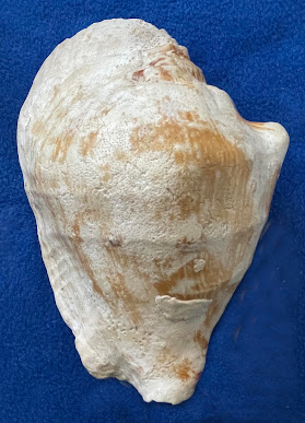
ONE VERY HEAVY CONCH SHELL

Order Littorinimorpha

Family Strombidae (the true conchs = gastropods)

Genus Sinustrombus [formerly in genus Strombus and subgenus Tricornis].

Species latissimus Linnaeus, 1758


There are many hybrids (varieties) of this marine-gastropod species.


Two views (apertural and abapertural) of a representative specimen (7 inches in length and 4.75 inches in width). The backside of this shell shows the effects of color bleaching by the sun. Also, notice the presence of many minute drill-holes in the shell; these are cause by sponges that lived on the "top" of the shell. This species lives in tropical waters (e.g., the Philippines, where people commonly use this gastropod as part of their diet). 


For its size, the shell of this species is one of the heaviest that I have even handled!

The solidness of its shell allows this species to live in extremely turbulent waters and/or has some formidable predators! 

Thursday, January 16, 2025

King Snake and Gopher Snake Examples from Southern California

One of my previous blogs focuses on some rattlesnakes that I have encountered while doing geologic field work in southern California. This present blog focuses, however, on two non-venomous snakes that I encountered while I was walking along a little-used dirt road in Towsley Canyon, just south of Santa Clarita, in northern Los Angeles County, southern California. 


The first of the two species I encountered is the:


California King Snake

    Family Colubridae

    Genus Lampropeltis

    Species californiae


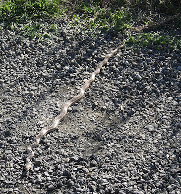
I encountered this snake while it was on the dirt road. The snake was inert for awhile, but before I could get a measurement as to its length, the snake quickly sped off into the weeds. Typically, king snakes are 2.5 to 3.5 feet long. Their coloration is variable, ranging from black and white to black and yellow.


On the same day, later in the afternoon while hiking on the same road (in the same general area of the previous snake I saw), I came across a "Pacific Gopher Snake:"


Pacific Gopher Snake

  Family Colubridae

  Genus Pituophis

  Species P. catenifer 

  Subspecies catenifer


This kind of snake is active during the day, thus it is one of the most commonly seen snakes. 


The first photo shows the head and the typical two to three rows of spots on the sides of this gopher snake.


The second photo shows how its body can be “kinked.”


The third photo was taken just before the snake (now "unkinked") turned around and “took off” like a “rocket” for the nearby weeds. Just before it did, however, I was able to get a measurement of its length (about 90 cm) by placing, parallel to the snake, my "Jacob Staff" (= a common tool used by field geologists for measuring the thickness of rock layers; each red or white segment is 10 cm long). The Jacob Staff is also a great hiking “stick.” The head of the snake, which is on the left side of the photo, is obscured by rocks in the road. The posterior of the snake is obscured by vegetation on the side of the road.


You never know what you might see when being in the field: that is one the alluring aspects of doing field work. By the way, I encountered both snakes near dwellings along a small stream. It is apparent that wherever a human builds a structure (especially near a stream), rodents will eventually find it to be good place to live. And, of course, snakes eat rodents.

Wednesday, January 8, 2025

A MOST UNUSUAL CLAM

This clam, which is commonly referred to as the “”watering pot clam” or the “water spout clam,” is one of the world’s most unusual clams [if not THE MOST unusual clam!]. Its early growth stage is totally different than that of the adult stage. Its shell begins as a normally shaped clam with two tiny embryonic valves, but they soon become covered as new shell is secreted over them. The right valve becomes incorporated into a thin long tube (a.k.a., siphonal tube), and the left valve becomes incorporated into an unusual-looking inflated disc with tiny perforations. The left valve also is vertically partially buried in sediment. For orientation purposes, the buried (bulbous) end is referred to as the anterior-most part of this bivalve, whereas the long tube is the posterior part. 

A


C

Three views of the same shell, A-C, (10 cm long = 4 inches) of Verpa  from the Singapore, China area.  A. Side view of entire shell. B. Posterior end of shell. C. Anterior end of shell (disk somewhat broken on its top edge).


As the shell of Verpa grows, it becomes more deeply burrowed, and the long-part of the tube can become bent or curved because of growth disturbances. The tube is not cemented to other shells nor to the substrate, but grains of sand and small pebbles and shell fragments may adhere to the thin calcareous tube. The end of the tube, that is buried in the sediment, ends in a fringed-thin disk, and beyond that, a bulbous disk that bears numerous tiny perforations (holes) open to the environment (like a shower head). This fringed disc with perforations is unique among bivalves. 


The shell tube can be up 12 cm (5 inches) long. This clam is a filter feeder that prefers to live among sea grasses growing on muddy/sandy ocean-floor conditions. This clam, furthermore, is known to occur in shallow-tropical waters from the Indian Ocean to the East Indies (especially the Singapore, China and the Philippines), but, apparently is becoming increasingly uncommon/rare [with some local extinctions having taken place]. Although five species have been reported in the literature over the last many years, it might be that this bivalve is on the verge of going extinct.


Classification: 

Phylum Mollusca

Class Bivalvia

Order indeterminate (not well established) possibly Anmalodesmata

Family Clavagellidae 

Genus Verpa [see WoRMS, 2024 at---http://www.marinespecies.org]

Species: Five named species and many synonyms.


The earliest known clavagellids that might be ancestral to Verpa are of late Mesozoic age (100 to 66 million years ago).


If you want to learn more about tube-dwelling bivalves and their adaptations, read the very interesting paper by Savazzi (1982). [It is a useful and interesting guide to all of the various types of these bivalves]. Note: When Savazzi wrote his paper, he used used the now no-longer-used name "Penicillus" for the tube-dwelling bivalve discussed in this present blog.


Reference: 

Savazzi, E. 1982. Adaptations to tube dwelling in the Bivalvia. Lethaia, v. 15, no. 3, pp. 275–297.


Additional Useful Literature:

DeLany, S. T. 1971, “It’s a Bivalve, You Know.” The Tabulata, April 1, 1971, pp. 20-21. 


Wednesday, January 1, 2025

AN INTERESTING GEOLOGIC FOLD SYSTEM IN PAKISTAN

This post concerns a Google-Earth image in southeastern Pakistan, where a noticeable fold system trends northwardly toward the Himalaya Mountain region (Figure 1). I shall very briefly discuss the geology of each main part of this fold system. Note: Prior to 1976, there was little or no geologic mapping in this region of Pakistan.


Figure 1. Google-Earth image of southeastern Pakistan.  


Figure 2. The area pertinent to the text in this blog is located near the right side of the above-shown map (just left of the two red lines with arrows--located just left of the word "Delhi." This base map is from the “The Earth’s Fractured Surface,” published by the National Geographic Society (1995). At the southern end of the "Arabian Plate" on this map is a heavy, red line with “teeth,” indicating the presence of the Makram Suduction-Zone trench.


Figure 3. Sketch map of the geology showing the geology between the Kirthar Mountains, Makran, the Makram Mountains, the Bruhui Mountains, the Sulaiman Mountains, and the Hindu Kush Mountains.


Overview of the lithology, etc., found in each of the above-   mentioned mountain ranges:


Makran Mountains: 600 miles (1,000 km) long, bordering the shore of the Arabian Sea, these mountains represent an accretionary prism consisting of Lower Paleozoic and Mesozoic ophiolites (i.e., metamorphic “basement rocks.”) Subsequently, these rocks had a complicated geologic history that started with turbidite sedimentation, followed, during the Miocene, by deposition of thick reef limestones. There was intense tectonic dislocation at the end of the Miocene, followed by subduction (along a trench just offshore in the adjacent Arabian Sea). During Plio-Pleistocene time, there was uplift and spectacular deposition of Plio-Pleistocene fanglomerates. In the “big picture of geologic history,” the Makram area geologically was situated in adjacent to a fore-arc zone area during the Cenozoic (McCall, 1997). 


The southern margin of the Makran Mountains is just north of an active convergent boundary (i.e., the Makran Trench or Makram Subduction Zone), where the Arabian Plate is presently subducting beneath the Eurasian Plate at the rate of 2 to 4 cm/year. This subduction has caused strong compressive forces that strongly folded the Makran and Bruhui Mountain Ranges into a composite “S” shape. This shape is very noticeable on Google Earth satellite images.


The subductive forces in the Makran and Bruhui Range have caused offshore cold seeps of gases, as well as, mud volcanoes (e,g., Zalzala Jazeera “island” that formed in 2013; it subsequently was destroyed by ocean-wave action) (see Wikipedia). 


Kirthar Mountains: 190 miles (300 km) long (south to north). Rocks in the southern and middle part are mainly shale of middle Eocene age; those in the northern part are mainly limestone. The highest peak is 9,498 feet (2,895 m). The subductive forces in the Makram and Bruhui Range have caused offshore cold seeps of gases, as well as, mud volcanoes (e,g., Zalzala Jazeera “island” that formed in 2013; it subsequently was destroyed by ocean-wave action) (see Wikipedia). 


Bruhui Mountains: 225 mi (360 km) long in a series of parallel limestone ridges. The highest peak is 11,738 feet (3,578 m). The highest peak in the Brahui Range is 11,738 feet (3,578 m) high.


Sulaiman Mountains: Represent a transitional zone between the geology of the Bruhui Range and the Hindu Kush Mountains. The highest is 11,099 feet. As India tectonically moved northward, it wrenched westward, collided with this part of Pakistan, and produced some of the most unusual looking plunging folds known on Earth. 


Hindu Kush Mountains: 800-km-long mountain range; the eastern end merges with the Karakoram Range. The Hindu Kush Mountains consist of metamorphic rocks (schist, gneiss, marble, and also granite intrusives). 


References Cited:

McCall, G.J.H. 1997. The geotectonic history of the Makran and adjacent areas of southern Iran. Journal of Asian Earth Science, v. 15, issue 6, pp. 517-531. Abstract is available for free, but the pdf of the paper costs $.


National Geographic Society, April, 1995. A loose fold-out map, with the title: The Earth’s Fractured Surface. Scale 1:48,000 or 1 inch = 758 miles at the equator.